Rohit Mukherjee, Ph.D.
I'm a Postdoctoral Researcher at Pacific Northwest National Laboratory's Atmospheric, Climate, and Earth Sciences (ACES) Division, where my work sits at the intersection of satellite remote sensing, deep learning, and Earth and urban climate science.
I develop and apply deep learning and AI methods, from convolutional and transformer-based segmentation models to geospatial foundation models, to extract more reliable information from multi-sensor satellite imagery (Sentinel, Landsat, MODIS, PlanetScope). I currently map urban floods, monitor surface water at global scale, assimilate urban vegetation data to improve climate models, and detect the expansion of informal roads in protected areas.
Before PNNL, I was a postdoctoral researcher at the University of Arizona, and I earned my PhD in Geography at The Ohio State University, where my dissertation used deep learning to enhance and fuse multi-sensor satellite imagery. Across these roles, my focus has stayed on building methods that make Earth observation more accurate, accessible, and useful for societally relevant science.
Latest Work
- Talk: Evidence of chronic flooding from a global 10-meter flood-occurrence dataset (AGU 2025).
- Talk: Global urban–rural contrasts in vegetation amount, subtypes, structure, and dynamics, modulated by background conditions (AGU 2025); preprint on Research Square.
- Paper: Integrating optical and SAR data enables crown-level maps of an emergent tree species, Dipteryx panamensis (Remote Sensing Applications: Society and Environment, 2026).
- Dataset: Urban Flood Observations (UFO): A hand-labeled training and validation dataset of post-flood inundation (arXiv preprint, 2026).
Table of Contents
- Research Projects
- Publications
- Lab Contributions
- Grant Proposals
- Dissertation
- Awards
- Teaching Experience
- Education
- Industry Experience
- Field Work
- Service
Urban Flood Mapping
A NASA Terrestrial Hydrology Project (#80NSSC21K1341). PI: Beth Tellman.
Mapping urban floods is challenging because the urban landscape is complex and heterogeneous. To address this, we built Urban Flood Observations (UFO!), a hand-labeled dataset that captures urban flooding across 14 cities worldwide using PlanetScope imagery.
Paper: arXiv:2604.23066 · Dataset: Zenodo
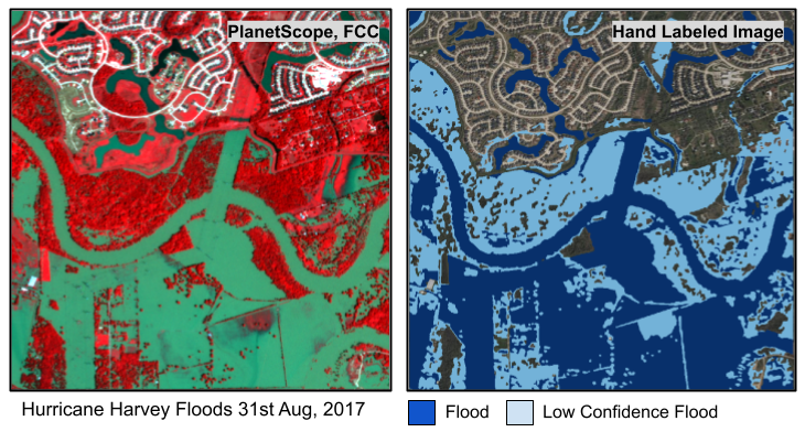
A sample from our training dataset built using Labelbox. Source: Planet.
My talk, Mapping Floods using Earth Observation and AI, on the IEEE GRSS YouTube channel.
NASA CSDA (#80NSSC21K1163) funded project on developing a global high-resolution hand-labeled flood extent mapping training and validation dataset called FloodPlanet. Link to paper.
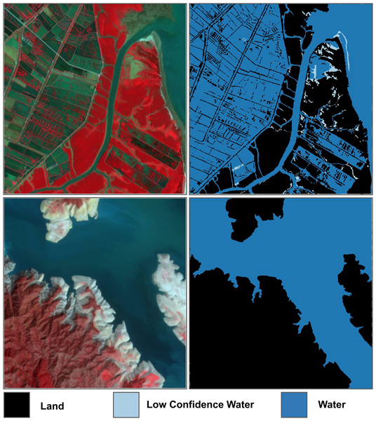
topGlobal Surface Water Mapping
A NASA ACCESS Project (#80NSSC22K0744). Working with Fritz Pollicelli and Beth Tellman.
We need validation datasets to evaluate the hundreds (thousands?) of surface water mapping methods using satellite imagery. We built a globally sampled hand-labeled dataset using PlanetScope imagery. We built a Sentinel-1 model trained on Dynamic World-based weak labels data that outperforms NASA's IMPACT flood dataset. We are now applying this model to extract river width globally on-demand using Sentinel-1 data for all river reaches from the impressive SWORD dataset. We are manually calculating effective river width using PlanetScope and then verifying using SWOT data.
Paper: Earth System Science Data
NASA CSDA (#80NSSC21K1163) funded project on evaluating BlackSky, where I am a Co-Investigator.
topDesert Floods in Pima County, Arizona
A Pima County Flood Control District project in Arizona.
This project focused on mapping fast-moving floods in the Sonoran Desert, which are difficult to capture with conventional surface-water methods. Instead, we used PlanetScope imagery to identify wet soils following rainfall events as a measure of flood extent. We then compared these results with the locations of recorded road closures to identify additional areas that may warrant road closures during future flooding.
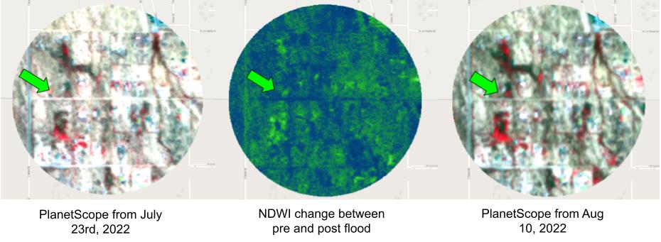
Identifying regions where it flooded, but there weren't any road closures for safety. Source: Planet.
topInformal Roads in Central America's Protected Forests
A NASA LCLUC Project (#80NSSC21K0297), in collaboration with Beth Tellman, Nicholas Magliocca, Matthew Fagan, Steven Sesnie, Erik Nielsen, Jennifer Devine, and Kendra McSweeney.
This project examines how narco-trafficking drives deforestation in Central America, using informal roads as an indicator. We developed a locally trained deep learning model that outperforms Microsoft and OpenStreetMap (OSM) in road identification. To analyze road growth since 2001, we use Landsat 7 alongside additional data sources to construct a counterfactual model assessing the impact of narco-trafficking on deforestation.
Paper: International Journal of Geographical Information Science
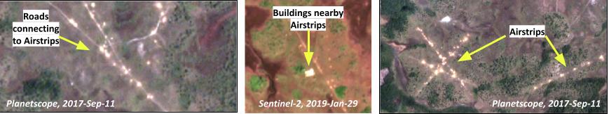
Markers of narco-trafficking in Central America. Sources: Planet and ESA.
topAssessing Intervention Programs by USAID
Funded by USAID's Bureau for Humanitarian Assistance (BHA), in collaboration with the University of Arizona's Institute for Resilience (AIR) and the Economics and Sociology Departments.
This project develops metrics to assess the impact of BHA-funded programs delivered through local NGOs, which aim to drive behavioral and landscape changes, particularly in response to disasters. Our focus is on capturing landscape changes using satellite remote sensing, providing BHA with tools to evaluate the impact of these programs.
Paper: International Journal of Disaster Risk Reduction
topPublications
- Diana W. Githu; Zack Guido; Erica A. Goto; Corrie Hannah; James Kamunge; Eligah Mutanda; Tim J. Finan; Padraic Finan; Karyn M. Fox; Suzanne Nelson; Prashanti Sharma; Rohit Mukherjee. (2026). Humanitarian assistance and its expected behavior and land use changes: Insights from Bangladesh and Kenya. International Journal of Disaster Risk Reduction, 106036.
- Mukherjee, Rohit; Chakraborty, T. C. (Submitted). Background climate and socioeconomic conditions constrain global urban–rural contrasts in vegetation amount, subtype, and structure. Science Advances.
- Zhang, Zhijie; Giezendanner, Jonathan; Mukherjee, Rohit; Tellman, Beth; Melancon, Alexander; Purri, Matt; Gurung, Iksha; Lall, Upmanu; Barnard, Kobus; Molthan, Andrew. (2025). Assessing inundation semantic segmentation models trained on high-versus low-resolution labels using floodplanet, a manually labeled multi-sourced high-resolution flood dataset. Journal of Remote Sensing, 5, 0575.
- Magliocca, Nicholas R; Sink, Carter D; Devine, Jennifer A; Fagan, Matthew E; Aguilar-Gonzalez, Bernardo; McSweeney, Kendra; Mukherjee, Rohit; Nielsen, Erik A; Sesnie, Steven E; Tellman, Beth. (2025). A data pedigree system to support geospatial analyses of human-environment interactions in data poor contexts. International Journal of Geographical Information Science, 39(6), 1223-1246.
- Mukherjee, Rohit; Policelli, Frederick; Wang, Ruixue; Arellano-Thompson, Elise; Tellman, Beth; Sharma, Prashanti; Zhang, Zhijie; Giezendanner, Jonathan. (2024). A globally sampled high-resolution hand-labeled validation dataset for evaluating surface water extent maps. Earth System Science Data, 16(9), 4311-4323.
- Mukherjee, Rohit; Liu, Desheng. (2023). Spatial and spectral translation of Landsat 8 to Sentinel-2 using conditional generative adversarial networks. Remote Sensing, 15(23), 5502.
- Giezendanner, Jonathan; Mukherjee, Rohit; Purri, Matthew; Thomas, Mitchell; Mauerman, Max; Islam, AKMl; Tellman, Beth. (2023). Inferring the past: A combined CNN-LSTM deep learning framework to fuse satellites for historical inundation mapping. Proceedings of the IEEE/CVF conference on computer vision and pattern recognition, 2155-2165.
- Mukherjee, Rohit; Liu, Desheng. (2021). Downscaling MODIS spectral bands using deep learning. GIScience & Remote Sensing, 58(8), 1300-1315.
- Patel, Nilanchal; Mukherjee, Rohit. (2015). Extraction of impervious features from spectral indices using artificial neural network. Arabian Journal of Geosciences, 8(6), 3729-3741.
Lab Contributions
- Mentored and co-supervised PhD and graduate students at the University of Arizona: Elise Arellano-Thompson, Ruixue Wang, Hannah Friedrich, and Prashanti Sharma.
- Built and maintained the lab's computational infrastructure.
- Developed a curriculum for training PhD students towards applying deep learning solutions to geospatial problems.
- Delivered hands-on machine learning and deep learning training to PhD students.
Grant Proposals
- Co-wrote a successful proposal titled - "Enhancing the Evidence for Humanitarian Action (EEHA) in the Face of Climate Change" with Arizona Institute for Resilience, funded by USAID's BHA (total award: $1,000,000).
- Collaborated on internal grants at PNNL ($55,000 funded).
- Wrote four proposals that were not funded, including one for NASA's use of Capella SAR data.
PhD Dissertation
"Improving Satellite Data Quality and Availability: A Deep Learning Approach"
This research involved improving the quality (spatial, spectral resolutions) and availability (temporal resolution) of existing satellite image products using deep learning models. The study focused on utilizing techniques such as deep residual encoder-decoder networks and generative adversarial networks to enhance satellite images from sources like MODIS, Sentinel-2, and Landsat 8. The work is aimed to advance satellite image fusion methodologies for various applications.
Investigated several aspects of applying convolution networks and generative adversarial learning on satellite imagery. Asked and answered questions on optimal loss functions including adversarial learning. Demonstrated the advantages of fine tuning on your region of interest among several other insights! Spending hours deep learning training models (and failing most experiments) is at least helping me save time now.
Two peer-reviewed papers came out of this work:
- Downscaling MODIS spectral bands using deep learning (GIScience & Remote Sensing, 2021).
- Spatial and spectral translation of Landsat 8 to Sentinel-2 using conditional generative adversarial networks (Remote Sensing, 2023).
Awards
- Lakshmanan Chatterjee Fellowship for Outstanding PhD Student - Department of Geography, Ohio State University, 2019
- Cognizant Internal Awards - Individual and Team awards for reduction of operation cost through the development of Automation Tools, Cognizant Technology Solutions, 2014
Teaching Experience
- Fundamentals of GIS - SU17, SU18, SU19 (In-person), SU20 (Online)
- Geographic Applications of Remote Sensing - AU16, SP19, SP20 (Graduate)
- Spatial Systems and Modelling - AU19 (Graduate)
- Spatial Data Analysis - AU18 (Graduate)
- Mapping Our World - SP18 (Undergraduate)
- Cartography - AU17 (Graduate)
- Geospatial Databases - AU16 (Graduate)
- Guest Lectures: Geographic Applications of Remote Sensing - AU16, AU21 (in University of Arizona), SP19 (Graduate), Spatial Data Analysis - AU18 (Graduate).
Independently taught four summer graduate-level courses between 2017 and 2020, and served as a teaching assistant across a range of courses each semester. In response to the COVID-19 pandemic, converted an in-person GIS course to a fully online format on short notice. In an earlier role, led three weekly labs and graded assignments for approximately 144 students in a single course.
Student Evaluation of Instruction (SEI) scores improved over the course of the PhD, consistently exceeding departmental and university averages.
topEducation
- Ph.D., Geography, The Ohio State University (AU 2016 - SU 2020)
Focus Areas: Remote Sensing, Deep Learning
Advisor: Dr. Desheng Liu - M.Sc., Geo-Informatics, Birla Institute of Technology, Mesra, India (2011 - 2013)
Thesis: "Extraction of Impervious Features through Artificial Neural Network using Spectral Indices"
Advisor: Dr. Nilanchal Patel - B.Sc., Computer Science, St. Xavier's College, Kolkata, India (2008 - 2011)
Thesis: "A Social Networking Website for Academics (SharEd)"
Industry Experience
Cognizant Technology Solutions, Programmer Analyst, 2013 - 2015.
Developed a VBA script to extract data from a legacy DOS application used for ESCROW processing, automating manual data entry and reducing processing time by approximately 85%. Also built a web-based interface for ServiceNow ticket processing using C# and ASP.NET.
topField Work
Visited Costa Rica in the summer of 2023 with Prof. Matt Fagan and grads Elise and Felipe to collect training and validation data for mapping land use/cover and roads.
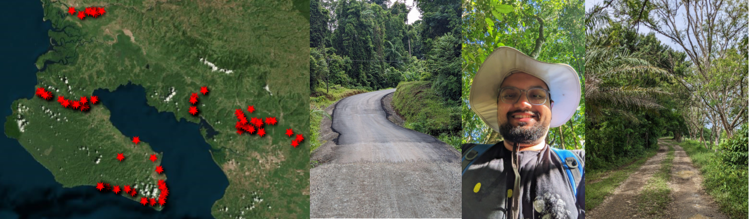
From left to right: all collected road validation points in the Osa Peninsula, Costa Rica; unpaved roads constructed from asphalt and gravel sourced from nearby rivers, which frequently leads to misclassification between the two surface types; a field site in Corcovado National Park; and roads bordering oil palm plantations.
topAcademic Service
- NASA Peer Review Panel (2023): Invited to review multiple proposals for potential funding.
- College of Arts and Sciences Dean’s Student Advisory Board (2019-20): Provided feedback to the Dean of Arts and Sciences on graduate student issues and concerns.
- Delegate - Council of Graduate Students (2018-20)